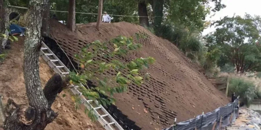
We recently inspected a site near the Birmingham Canal Navigations where topsoil had washed down a 6 m slope after two wet weeks. The client needed to know if the erosion would affect a planned retaining wall. We ran field infiltration tests and took undisturbed block samples from the exposed horizon. Back in the lab we measured dispersivity, particle size distribution and organic content. That data let us calculate the expected long-term erosion rate under local rainfall patterns. Before finalising the design we also recommended a drainage geotechnical assessment to control surface water and a slope stability analysis for the cut face. For Birmingham sites with clayey subsoil this combined approach gives the owner a clear picture of future maintenance costs and safety margins.
On Birmingham clay slopes we measure dispersivity in the lab; on sandy river terraces we focus on infiltration rates. Each site needs its own protocol.
Scope of work in Birmingham
Critical ground factors in Birmingham
Eurocode 7 (EN 1997-1:2004) requires that geotechnical designs account for water-induced deterioration over the structure's lifetime. In Birmingham that means soil erosion is a real risk, especially on embankments built from the local Mercia Mudstone. That material can soften and slake when exposed. If the erosion is not quantified early, fine particles can clog drainage systems or reduce the bearing area of shallow foundations. We have seen cases where a 2 % slope lost 30 mm of topsoil in one winter, exposing the root zone of trees and increasing the risk of windthrow. Our analysis includes long-term scenarios of 10 and 50 years so the engineer can decide on protective measures such as geotextiles or vegetation cover.
Our services
We offer two specific services to help Birmingham engineers and developers manage erosion risk before and during construction.
Field Erosion Risk Survey
We walk the site, log slope angles, soil types and vegetation cover, then run in-situ infiltration tests and collect samples for lab dispersivity testing. The output is a simple risk matrix that grades each slope from low to high erosion potential.
Laboratory Soil Dispersivity Suite
Using the pinhole test, crumb test and double hydrometer (BS 1377), we classify the clay's tendency to disperse in water. This is critical for Birmingham's glacial tills and mudstone derived soils where hidden dispersivity can cause sudden erosion after rainfall.
Q&A
How much does a soil erosion analysis cost in Birmingham?
A standard field survey with laboratory dispersivity testing typically ranges from £600 to £2,000 depending on the number of slopes, access conditions and the suite of lab tests required. Contact us for a fixed quote based on your site dimensions.
What's the difference between rill and gully erosion on Birmingham slopes?
Rill erosion forms small, shallow channels that can be smoothed over by tillage or light grading. Gully erosion cuts deeper than 300 mm and usually requires engineering intervention such as regrading or drainage installation. Our analysis identifies which type is active and whether it is progressing.
Do I need an erosion analysis for a small housing development in Birmingham?
Yes, if your site has slopes steeper than 1:10 or borders a watercourse. Birmingham City Council often requests an erosion assessment during the planning stage, especially on brownfield sites near the canal network or the River Rea. We can provide a concise report that satisfies the local authority.