The contrast between Birmingham's sandstone ridges and the clay-filled valleys of areas like Moseley and Kingstanding means ground conditions can shift dramatically within a few hundred metres. In the city centre, where Triassic sandstones dominate, slopes are generally competent, but in the suburbs underlain by glacial till or the Mercia Mudstone Group, instability becomes a real concern. We see this especially after prolonged rainfall, when pore pressures rise and the effective stress in the soil drops. A thorough landslide assessment in Birmingham must account for these local variations, and we integrate that understanding with advanced analytical methods. Before any remediation design, a proper in-situ shear strength test is essential to define the true resistance parameters of the slip surface, and we also recommend piezometric monitoring to track seasonal water table fluctuations that trigger reactivation.
A single piezometer installed for two wet seasons provides more actionable data than ten boreholes without groundwater monitoring.
Scope of work in Birmingham
- Walkover survey to map tension cracks, scarps, and drainage patterns.
- Boreholes with continuous sampling and SPT testing to define stratigraphy.
- Installation of standpipe piezometers for groundwater monitoring across a minimum of two wet seasons.
Critical ground factors in Birmingham
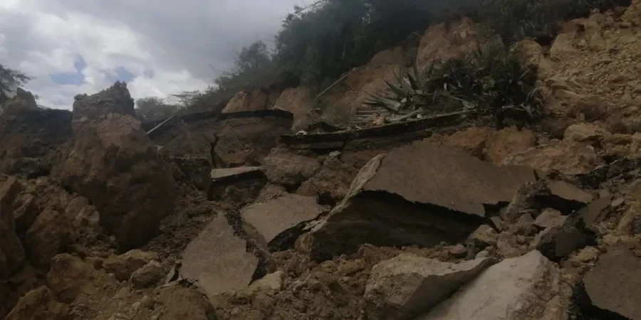
A recurring mistake we see among developers in Birmingham is commissioning a single-phase geotechnical desk study and then proceeding directly to foundation design without a dedicated slope stability assessment. They assume that because the site has been stable for decades, it will remain so — ignoring the effect of cut-and-fill operations, garden irrigation, or blocked drainage that gradually raises pore pressures. In one case near the Lickey Hills, a housing development lost two rear gardens to a shallow translational slide after a wet winter, simply because the original ground investigation had not considered the perched water table above the mudstone. A proper landslide assessment would have identified that risk and recommended a drainage blanket before topsoil stripping began.
Our services
We provide two complementary services tailored to Birmingham's geology: a detailed site investigation for landslide assessment, and a targeted remediation design service to stabilise active or dormant slopes.
Detailed Landslide Investigation
Combines walkover survey, trial pitting, rotary boreholes, and laboratory testing (triaxial, direct shear, index properties) to characterise the failure mechanism. Includes piezometer installation and at least two wet-season monitoring cycles. Deliverables include a stability analysis report with factors of safety under drained and undrained conditions.
Slope Remediation Design
Based on the investigation findings, we design cost-effective solutions such as soil nailing, drainage trenches, retaining walls, or regrading. All designs are checked against Eurocode 7 and the specific groundwater regime of the site. We provide construction drawings, specification clauses, and supervision support during installation.
Q&A
How much does a landslide assessment cost in Birmingham?
Typical costs for a residential-scale landslide assessment in Birmingham range between £820 and £2,680, depending on site access, number of boreholes, and monitoring duration. Larger or more complex sites — such as those requiring deep rotary coring or multiple piezometers — will be at the higher end. Contact us for a site-specific quotation.
What triggers landslides in the Birmingham area?
Most landslides in Birmingham are triggered by prolonged or intense rainfall that raises pore water pressure within the Mercia Mudstone or glacial till. Human factors — such as excavation for basements, removal of toe support, or leaking drainage pipes — are also common contributory causes. The combination of clay-rich soils and steep valley sides makes areas like Kings Heath and Edgbaston particularly susceptible.
Is a landslide assessment required by UK building regulations?
While there is no blanket statutory requirement, the NHBC and most local planning authorities will require a geotechnical assessment if a proposed development is within 15 metres of a slope steeper than 1:3. Additionally, the Building Regulations Approved Document A (Structure) requires ground movement risk to be considered, and a landslide assessment is the accepted method for demonstrating compliance on sloping sites.
How long does a full landslide assessment take?
A standard investigation — including field work, laboratory testing, and reporting — takes 6 to 10 weeks. If groundwater monitoring is required over two wet seasons, the programme extends to approximately 12 to 14 months. We can provide interim reports for planning purposes after the first monitoring cycle.
What is the difference between a desk study and a landslide assessment?
A desk study reviews existing records, geological maps, and historical aerial photos to identify potential ground hazards. A landslide assessment goes further: it involves physical site investigation (boreholes, trial pits, geophysics), laboratory testing for shear strength parameters, installation of monitoring instruments, and quantitative slope stability analysis. The desk study is a useful first step, but it cannot replace the site-specific data that a full assessment provides.