Birmingham sits on a complex Triassic sandstone and Mercia Mudstone sequence, with glacial till deposits in the river valleys. The bedrock depth varies dramatically across the city, from near-surface in the Jewellery Quarter to over 20 meters in parts of Edgbaston. Seismic tomography provides the velocity profile needed to map these layers with precision. Refraction surveys pick up the first-arrival P-waves, ideal for defining the top-of-rock contact. Reflection surveys image deeper stratigraphy and fault structures. Combining both methods gives a continuous 2D or 3D model of the subsurface. This is particularly valuable where borehole data is sparse or expensive to obtain.
Refraction tomography resolves velocity contrasts of 20% or more, making it ideal for mapping sandstone bedrock beneath glacial till.
Scope of work in Birmingham
Critical ground factors in Birmingham
Birmingham's urban expansion during the Industrial Revolution created extensive made-ground zones, particularly around Digbeth and the canal network. Old mine workings and backfilled quarries add further complexity. A seismic tomography survey without careful source-receiver geometry design can miss these heterogeneities. The key risk is interpreting a smooth velocity gradient when the actual subsurface has abrupt lateral changes. The solution is to use a dense geophone spacing (2 meters or less) and multiple shot points. This ensures that voids, rubble zones, or buried structures are resolved before foundation design begins.
Our services
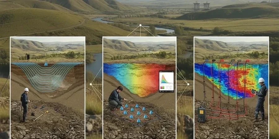
We offer two main configurations of seismic tomography to match different project requirements and site conditions in Birmingham.
Refraction Tomography (P-wave velocity model)
Uses first-arrival travel times to build a 2D velocity section. Best for mapping the top of bedrock, depth to refusal, and weathering profiles. Ideal for highway cuts, building foundations, and landfill investigations.
Reflection Tomography (Shallow seismic reflection)
Captures reflected P-waves from subsurface interfaces. Resolves thin layers and dipping strata that refraction misses. Applied to fault detection, coal seam mapping, and deep foundation design in Birmingham's sandstone aquifer.
Q&A
What is the difference between refraction and reflection seismic tomography?
Refraction tomography uses the first-arriving P-waves that travel along the fastest path through the ground; it is best for mapping velocity layering and the top of bedrock. Reflection tomography records reflected waves from subsurface interfaces and can resolve thin layers, faults, and dipping structures. In Birmingham, refraction is commonly used for foundation depth assessment, while reflection is applied where detailed stratigraphic imaging is required.
How deep can seismic tomography penetrate in Birmingham's geology?
Refraction surveys typically achieve depths of 10 to 30 meters, depending on the energy source and geophone spacing. Reflection surveys can reach 50 meters or more. In Birmingham, the sandstone bedrock is often within this range, making both methods suitable for most infrastructure projects.
Does seismic tomography work on made ground or backfilled sites?
Yes, but the resolution depends on the velocity contrast between the fill and the natural ground. Made ground with rubble or voids can produce strong reflections or shadow zones. Dense geophone spacing (2 meters) and multiple shot points are used to characterise these heterogeneous zones. A complementary borehole SPT can validate the velocity model.
What is the typical cost range for a seismic tomography survey in Birmingham?
The cost depends on the survey length, geophone spacing, and number of shot points. A typical refraction tomography survey for a 100-meter line with 24 channels ranges from £2,210 to £4,570. Reflection surveys with longer spreads and higher channel counts are at the upper end of that range. Final price is confirmed after site visit and scope definition.